

Yellowstone River Information
Overview
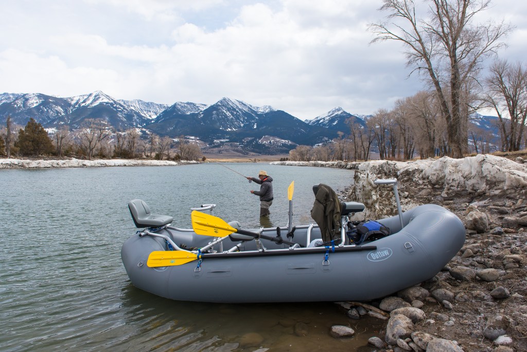
The Majestic Yellowstone River, flowing out of Yellowstone national park and dumping its waters into the Missouri River, is the longest freestone river in the United States. The Yellowstone River is world renown for it’s incredible trout fishery in its upper reaches. The best trout fishing on the Yellowstone lies between the towns of Gardiner Montana and Big Timber Montana. Fantastic fishing can be had upstream in Yellowstone National Park and below Big Timber, however this page will break down those sections that both can be floated and contain fantastic trout fishing. Scroll down for current streamflow.
The Yellowstone is a relatively high volume river, consisting of plenty of structure to hold both native and non native fish species. The upper reaches contain predominantly Cutthroat (native) and Rainbow (non-native) with the occasional Brown. Below Yankee Jim Canyon (constricted whitewater canyon) the brown trout become more plentiful. Of course you will catch plenty of our hungry native whitefish.
The Yellowstone River is perfectly suited to fishing from a raft or Drift Boat as it has numerous and regularly spaced boat ramps and river access points. Many shuttle companies operate along the river getting your truck and trailer conveniently to your desired take out.
The Upper
We consider the Upper to be the stretches of river between Gardiner, MT and Emigrant, MT. This section of water contains most of the whitewater found on the floatable sections of the Yellowstone River. The fishing between Corwin Springs and the start of Yankee Jim canyon can be phenomenal, just make sure you take out before the torrents of Yankee Jim Canyon.
The Middle
We consider the Middle to be the stretches of river between Emigrant, MT and Livingston, MT. This is arguably the most scenic section of water in the state of Montana, flowing through Paradise Valley. This section is home to healthy populations of trout and has regular caddis hatches throughout the summer. This section is also home to some pig bucknasty browns! If streamer fishing is your game, you’re up to bat!
The Lower
We consider the Lower to be the stretches of river between Livingston, MT and Big Timber, MT. The Yellowstone carries more volume through this stretch and is generally wider and more braided. This can present alot of good opportunities to park the raft and wade fish some of the braids. Some can be extremely productive and yield really nice fish. It should be noted that the boat accesses become much farther apart in this section of the River. Plan for longer days and longer floats. This section of water usually warms up first slowing the fish down in late Summer, however predatory browns can and will engage your presentation!
Top 3 Yellowstone River Floats
Yellowstone Float No. 1 – The Bird Float
Put In: Grey Owl | Take Out: Mallard’s Rest
The bird float can get busy, especially on weekends, but has the best scenic views of the Absaroka Mountains and some of the most consistently productive fishing on the Yellowstone River.
Yellowstone Float No. 2 – The Short Float
Maybe it’s just us but sometimes, you have to squeeze a short float in. Well you’re in luck, Carbella to Point of Rocks is one of the best “short” floats in the state as far as fishing and scenery goes. Mid summer this float takes around an hour and half. This short section of river offers a wide variety of structure making it very productive if you’re here between hatches, or at a slow time.
Yellowstone Float No. 3 – Pine Creek to Carter’s Bridge
We’ll preface this, with saying this can be a fairly sporty float. While there is no real whitewater on this section, the second half has some pool drops and sharp bends that require you to be on your toes and in good control behind the oars.
This section contains some really cool water, some big islands to wade from, and of course more spectacular views. This float is best once the river levels drop below 4000 cfs on the Livingston gauge (see below).